Changelog
Changelog
Keep track of the latest features and updates
Stay updated with the latest improvements, features, and enhancements powering smarter disaster risk management.


Nov 25, 2025
3.0.1
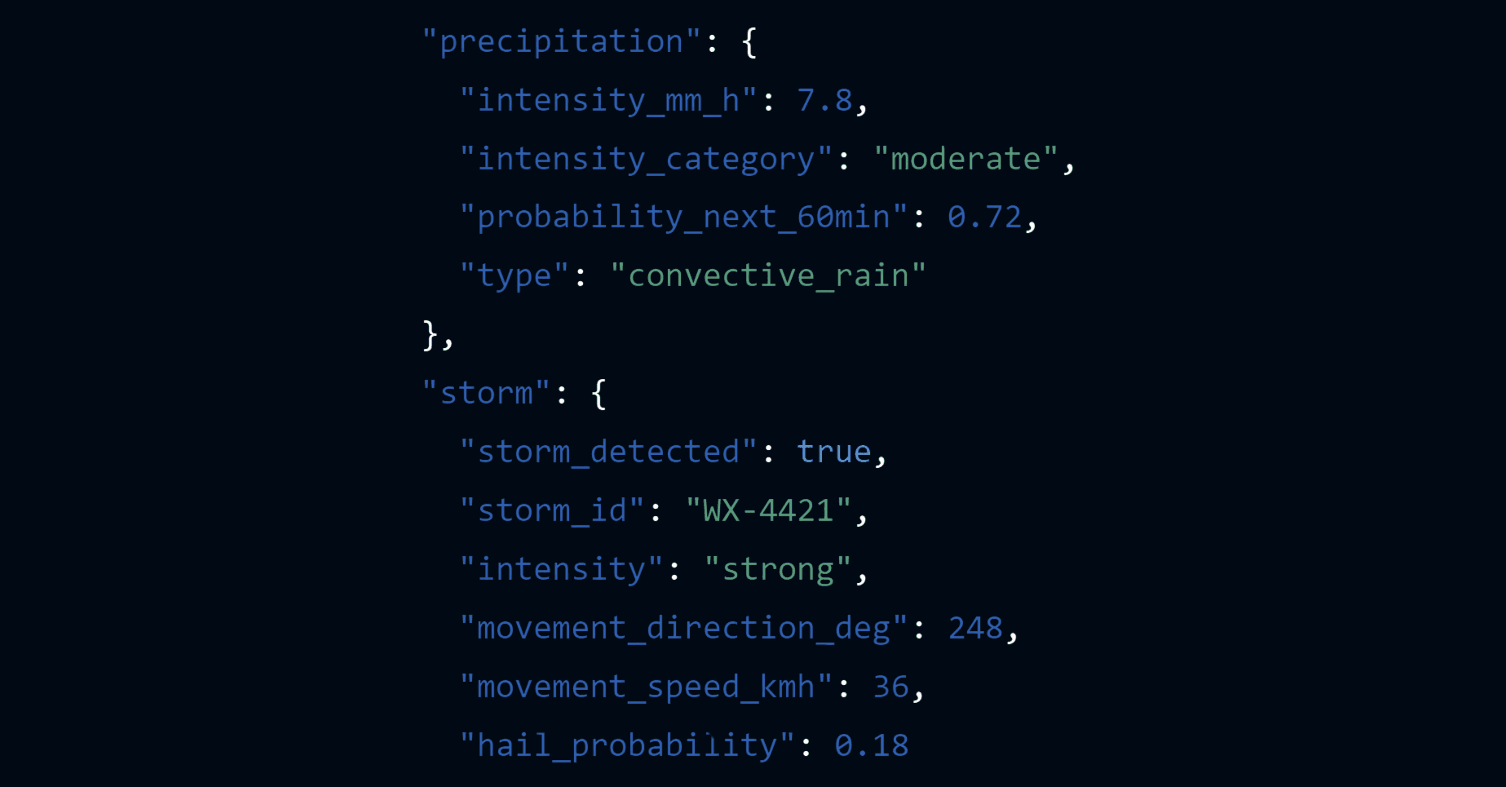
Real-Time Weather Intelligence for Developers
A powerful weather-risk API suite delivering real-time precipitation, cloud, storm, and lightning intelligence for any application.
Feature list
Precipitation API: hyperlocal intensity, probability & rain-onset timing
Storm Tracking API: live convective cells, movement, severity & hail chance
Lightning Alerts API: instant proximity detection & risk scoring
Risk Index API: flood risk, storm impact scores & operational thresholds
Welcome to WeatherX API — the next-generation platform for developers building applications that depend on real-time, high-precision weather intelligence.
Our API suite transforms raw satellite data, storm analytics, and atmospheric models into clean, developer-friendly endpoints. Retrieve hyperlocal precipitation intensity in milliseconds, classify clouds using AI-enhanced MTG imagery, track evolving storm cells, or trigger instant lightning alerts — all from a single, unified API.
WeatherX API is built for mobility apps, renewable energy platforms, logistics systems, emergency management tools, and any product that needs live weather-aware automation.
⚡ Available now
Start building with WeatherX today.
Nov 25, 2025
3.0.1
Real-Time Weather Intelligence for Developers
A powerful weather-risk API suite delivering real-time precipitation, cloud, storm, and lightning intelligence for any application.
Feature list
Precipitation API: hyperlocal intensity, probability & rain-onset timing
Storm Tracking API: live convective cells, movement, severity & hail chance
Lightning Alerts API: instant proximity detection & risk scoring
Risk Index API: flood risk, storm impact scores & operational thresholds
Welcome to WeatherX API — the next-generation platform for developers building applications that depend on real-time, high-precision weather intelligence.
Our API suite transforms raw satellite data, storm analytics, and atmospheric models into clean, developer-friendly endpoints. Retrieve hyperlocal precipitation intensity in milliseconds, classify clouds using AI-enhanced MTG imagery, track evolving storm cells, or trigger instant lightning alerts — all from a single, unified API.
WeatherX API is built for mobility apps, renewable energy platforms, logistics systems, emergency management tools, and any product that needs live weather-aware automation.
⚡ Available now
Start building with WeatherX today.
Sep 25, 2025
1.4.0
Community Features in WeatherX App
A new way to connect: users can now share live weather observations within the app.

Feature list
Share real-time observations (rain, thunder, strong winds, hail)
Add photos and comments for context
Community data feeds directly into model improvements
Interactive stream of weather reports near your location
We’ve introduced a community space inside the WeatherX App. Now forecasts don’t just come from models — they are enriched by the crowd. Live reports from users turn into a social weather layer, helping you validate conditions around you and boosting the accuracy of our predictions.
🌍 Update your app and share your weather story with the community.
Sep 25, 2025
1.4.0
Community Features in WeatherX App
A new way to connect: users can now share live weather observations within the app.
Feature list
Share real-time observations (rain, thunder, strong winds, hail)
Add photos and comments for context
Community data feeds directly into model improvements
Interactive stream of weather reports near your location
We’ve introduced a community space inside the WeatherX App. Now forecasts don’t just come from models — they are enriched by the crowd. Live reports from users turn into a social weather layer, helping you validate conditions around you and boosting the accuracy of our predictions.
🌍 Update your app and share your weather story with the community.
Aug 22, 2025
1.3.0
Map Layer & Live Radar Forecast up to 4h
The WeatherX App now features an interactive map and radar layer for hyperlocal tracking & nowcasting.

Feature list
Live precipitation radar layer with smooth animations
Cloud cover, temperature, and wind overlays
Zoom & pan for hyperlocal detail
Short-range radar forecast (1–3h storm evolution)
The WeatherX App now brings you an interactive map and radar experience. Track storm systems in real time, switch between multiple layers, and zoom in to your exact location. From sudden downpours to fast-moving cells, you can now see what’s coming with a single glance.
🌍 Open the app, switch on the radar layer, and follow the weather around you in real time.
Aug 22, 2025
1.3.0
Map Layer & Live Radar Forecast up to 4h
The WeatherX App now features an interactive map and radar layer for hyperlocal tracking & nowcasting.
Feature list
Live precipitation radar layer with smooth animations
Cloud cover, temperature, and wind overlays
Zoom & pan for hyperlocal detail
Short-range radar forecast (1–3h storm evolution)
The WeatherX App now brings you an interactive map and radar experience. Track storm systems in real time, switch between multiple layers, and zoom in to your exact location. From sudden downpours to fast-moving cells, you can now see what’s coming with a single glance.
🌍 Open the app, switch on the radar layer, and follow the weather around you in real time.
Aug 15, 2025
2.3.0
Marine Data for Smarter Operations
We’ve introduced a dedicated marine layer designed for shipping, offshore energy, and logistics operations.

Feature list
Global marine dataset integrated into WeatherX Portal and API
Wave height, direction, and period for route optimization
Currents, sea surface temperature (SST), and surface winds
Automated alerts for hazardous marine conditions
We’ve extended WeatherX with a dedicated marine intelligence layer. This enables shipping, offshore energy, and logistics operators to anticipate disruptive conditions at sea — not just wind and rain, but also waves, currents, and thermal anomalies. With marine alerts embedded in your workflow, you can minimize downtime, improve safety, and optimize routes.
👉 Explore the Marine section today — and make your offshore operations weather-resilient.
Aug 15, 2025
2.3.0
Marine Data for Smarter Operations
We’ve introduced a dedicated marine layer designed for shipping, offshore energy, and logistics operations.
Feature list
Global marine dataset integrated into WeatherX Portal and API
Wave height, direction, and period for route optimization
Currents, sea surface temperature (SST), and surface winds
Automated alerts for hazardous marine conditions
We’ve extended WeatherX with a dedicated marine intelligence layer. This enables shipping, offshore energy, and logistics operators to anticipate disruptive conditions at sea — not just wind and rain, but also waves, currents, and thermal anomalies. With marine alerts embedded in your workflow, you can minimize downtime, improve safety, and optimize routes.
👉 Explore the Marine section today — and make your offshore operations weather-resilient.
Jul 28, 2025
Version 2.2.3
Weather Risk Colors Added for Custom Alerts
Smarter visual cues for weather risk levels in business operations.

Feature list
WMO-compliant risk color scale now available in WeatherX rules.
Five-tier color code: Low, Moderate, High, Very High, Extreme.
Fully customizable alert creation based on thresholds and weather types.
We’ve integrated WMO's internationally recognized weather risk color coding system into our alert rule engine. This allows users to build alerts that are not only data-driven, but also visually aligned with global standards. Whether it’s a Heavy Rain in the Low category or Stormy Wind marked as Very High risk, businesses can now assign color-coded severity levels to their alerts — and quickly interpret operational danger at a glance.
The new risk palette includes:
🟢
No Risk– Pure Green🟢
Low– Enhanced Green🟡
Moderate– Yellow🟠
High– Orange🔴
Very High– Red🟣
Extreme– Purple
From now on, your dashboard won’t just show “rain” — it’ll show how critical that rain is for your operation. Want to trigger an automated workflow for storms exceeding High risk? Just set your rule and color level. As weather risk becomes more granular, your business decisions get sharper.
Jul 28, 2025
Version 2.2.3
Weather Risk Colors Added for Custom Alerts
Smarter visual cues for weather risk levels in business operations.
Feature list
WMO-compliant risk color scale now available in WeatherX rules.
Five-tier color code: Low, Moderate, High, Very High, Extreme.
Fully customizable alert creation based on thresholds and weather types.
We’ve integrated WMO's internationally recognized weather risk color coding system into our alert rule engine. This allows users to build alerts that are not only data-driven, but also visually aligned with global standards. Whether it’s a Heavy Rain in the Low category or Stormy Wind marked as Very High risk, businesses can now assign color-coded severity levels to their alerts — and quickly interpret operational danger at a glance.
The new risk palette includes:
🟢
No Risk– Pure Green🟢
Low– Enhanced Green🟡
Moderate– Yellow🟠
High– Orange🔴
Very High– Red🟣
Extreme– Purple
From now on, your dashboard won’t just show “rain” — it’ll show how critical that rain is for your operation. Want to trigger an automated workflow for storms exceeding High risk? Just set your rule and color level. As weather risk becomes more granular, your business decisions get sharper.
Jun 20, 2025
Version 2.2.1
Advanced Storm Tracking & Forecasting
Visualize and anticipate severe weather—globally.

Feature list
Global storm detection powered by WeatherX forecasting model.
AI-driven short-term forecasts for high-impact events.
Dynamic visualization of storm evolution and intensity.
Earth3D now lets you monitor storms —anywhere on Earth. Our advanced algorithms analyze atmospheric and satellite data to detect storm systems, predict their evolution, and visualize their impact zones. With animated layers, Earth3D supports both weather-sensitive businesses and individuals such as weather enthusiasts, outdoor explorers, and those at sea. From oceanic cyclones to fast-moving convective clusters, you get an immersive, data-rich interface for tracking threats before they escalate.
Take a glance at the interactive Earth3D in Beta version.
Jun 20, 2025
Version 2.2.1
Advanced Storm Tracking & Forecasting
Visualize and anticipate severe weather—globally.
Feature list
Global storm detection powered by WeatherX forecasting model.
AI-driven short-term forecasts for high-impact events.
Dynamic visualization of storm evolution and intensity.
Earth3D now lets you monitor storms —anywhere on Earth. Our advanced algorithms analyze atmospheric and satellite data to detect storm systems, predict their evolution, and visualize their impact zones. With animated layers, Earth3D supports both weather-sensitive businesses and individuals such as weather enthusiasts, outdoor explorers, and those at sea. From oceanic cyclones to fast-moving convective clusters, you get an immersive, data-rich interface for tracking threats before they escalate.
Take a glance at the interactive Earth3D in Beta version.
May 15, 2025
Version 1.0.0
WeatherX Plus – Weather, Reimagined
A beautifully designed weather app for people who live by the sky.

Feature list
Hyperlocal forecasts: hour-by-hour and 7-day outlooks
Smart alerts for severe weather near you or your favorite places
Optimized rainfall chances for your specific location
Welcome to WeatherX Plus — the future of personal weather, reimagined.
This first version brings a fully immersive, visually rich weather experience to your mobile device. Navigate a dynamic interface and precise forecasts at a glance. Built for adventurers, skywatchers, and anyone who wants weather that’s not just informative — but beautiful.
📲 Available now
Download for Android
Download for Apple/iPhone
May 15, 2025
Version 1.0.0
WeatherX Plus – Weather, Reimagined
A beautifully designed weather app for people who live by the sky.
Feature list
Hyperlocal forecasts: hour-by-hour and 7-day outlooks
Smart alerts for severe weather near you or your favorite places
Optimized rainfall chances for your specific location
Welcome to WeatherX Plus — the future of personal weather, reimagined.
This first version brings a fully immersive, visually rich weather experience to your mobile device. Navigate a dynamic interface and precise forecasts at a glance. Built for adventurers, skywatchers, and anyone who wants weather that’s not just informative — but beautiful.
📲 Available now
Download for Android
Download for Apple/iPhone
+

Buy Now